|
Northwest Las Vegas Tour |
|
 |
NORTHWEST LAS VEGAS
The northwest is bordered on the south by Charleston Blvd. and on the east By Rancho and Decator. The main hiways are State 95, which winds through the southern portion and then swings north as it meets Rainbow and the Summerlin Parkway. One would do well to avoid this intersection, called the "Rainbow Curve" during peak hours.
Building in this area will eventually extend north to
the Kyle Canyon Rd. (road to Mt. Charleston. At that
point the Las Vegas Paiute Indian Reservation land
continues northward. The reservation is home to the Las
Vegas Paiute Golf Resort (http://www.lvpaiutegolf.com/)
The southwest corner of the intersection of 95 and Ann Road is Painted Desert, a golf course community. A Jay Morrish designed 18 hole public course, it is one of the best maintained public course in Nevada. At the intersection of Hwy. 95 and Rancho you will notice the Sante Fe Station Hotel & Casino. The Sante Fe is a popular mecca for residents in this part of the northwest. It features ice skating, bowling, many fine restaurants, a buffet, bingo and of course "gaming". Continuing south on 95 we come to Craig Road, the most northerly east-west main artery in the city. It leads directly to the front gates of Nellis Air Force Base in the east and near to the base of Lone Mountain in the west. As we continue south on Hwy. 95, the next main interchange is Cheyenne. At the southwest corner is a large medical center and next to it, Sunrise Mountainview Hospital. Traveling east on Cheyenne we pass a variety of neighborhoods. Many of these homes date back to the 60's. After passing Jones and Decatur turn right on Rancho. Rancho is a favorite alternate to Hwy. 95 for folks who have to get downtown in a hurry. As you travel south, the North Las Vegas Air Terminal is on the east side. Air traffic here is mostly private planes, tours and helicopters. Looming on the horizon on the left side of Rancho are the signs for the Fiesta and Texas Station casinos. Turn right on to Lake Mead Blvd. By the way, there are two Lake Mead streets in town; Lake Mead BOULEVARD is the one in the north end (the one we're on) while Lake Mead DRIVE is in Henderson. As you pass Decatur note that there are smog testing businesses on each corner (each with a different price). In order for your automobile to be licensed in Nevada it will have to pass a smog emission test. Continue west on Lake Mead until you pass the Hwy. 95 interchange. As you travel past the shopping plazas please note that none of these were here two years ago, there were just open fields! As you pass Buffalo, The Pueblo village of Summerlin appears on your left. The Shores is on your right. If you would like a little side trip, turn right on Mariner and follow it north until you see a body of water. You may even see someone fishing from the shore of this man-made lake. As you continue, Mariner becomes Harbor Island and will lead you back to Lake Meade Blvd. Then turn right. From Rampart west, everything is the master plan Summerlin with Sun City on your right and the Hills village on the left. There are two Sun Cities in Las Vegas; on at Anthem in Henderson and this one in Summerlin. Sun City is an 55 year age-restricted community developed by the Del Webb Corporation. The community boasts three golf courses (Highland Falls, Palm Valley and Eagle Crest) numerous community centers, restaurants and a host of activities and clubs for seniors. Lake Mead will continue west to the construction of the Beltway interchange. If you feel adventurous follow the road to the top. As you turn around, get your camera ready for one of the most breathtaking panoramic views in the valley. You are now at an elevation higher than the top of the Stratosphere Tower. Come back down the hill past Anasazi and Snow Trail, Hillpointe and turn right on Hills Center (at the lights). Have you driven in Europe? Get ready. Turn right on Village Center and exit on Town Center. As you drive southwest on Town Center you will come to two "turnarounds" (European style... very exciting). On your right is the Summerlin Hospital and Medical Center. Follow Town Center south to Charleston Blvd. Charleston Blvd. is the major east-west artery in Las Vegas, divinding the north side of town from the south. If you travelled west on Charleston from Town Center you would soon reach Red Rock Canyon, a favorite getaway. We will turn left and travel east. As you leave Summerlin, at Hualpai (pronounced "whalpie"), you enter the Pecolle Ranch with Queensridge on your left. Look for the large horse statue at the entrance. Homes in Queensridge overlook the 27 hole Badlands Golf Club. Turn left on Ft. Apache and follow it north past Alta (Ft. Apache becomes Rampart). As you pass the Suncoast and Regent hotels (and casinos) turn right onto the Summerlin Parkway. Don't take the Buffalo exit but turn right on Rainbow. Gradually work your way into the left lane and turn left at Charleston. Going east on Charleston you can't help but notice the bright colors of the Community College of Southern Nevada buildings at Torrey Pines. Continue past Jones and Decatur and turn left at Valley View. The Las Vegas Valley Water District is on your right side. As a matter of fact they own all the land for a few blocks right up to Hwy 95. Turn right on Alta. On the left, the Water District's North Well Field is the sight of "Big Springs". The cottonwood trees in the distance are the sight of the original artesian wells to which original settlers flocked. Artifacts uncovered at this site include 5,000-year-old projectile points and Anasazi ruins. The current proposals for the widening of Hwy 95 have threatened this historic site but thanks to the Water District and the Las Vegas Springs Preserve Foundation 180 acres will be saved for nature walks and a botanical garden, set to open in 2005.
Continuing east on Alta we enter a neighborhood which
contains the homes of many celebrities; Kenny Rogers,
B.B. King, Phyllis McGuire (of the sisters) and many
more. Turning right on Rancho brings us to the lower east
side, and the end, of our tour. |
|
 We will
start our tour in the extreme north. This is an area that
is growing in leaps and bounds. The photo shows Durango
Blvd. as you exit east from Hwy. 95 toward the Sheep
Range. As you can see, many home builders are active in
this area. Eastward from the current construction are
many custom homes and horse ranches.
We will
start our tour in the extreme north. This is an area that
is growing in leaps and bounds. The photo shows Durango
Blvd. as you exit east from Hwy. 95 toward the Sheep
Range. As you can see, many home builders are active in
this area. Eastward from the current construction are
many custom homes and horse ranches. 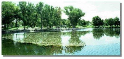 Durango will lead you
down towards Floyd Lamb State Park, a wonderful setting
for a family picnic and a chance to sit on the banks of a
natural spring fed pond.
Durango will lead you
down towards Floyd Lamb State Park, a wonderful setting
for a family picnic and a chance to sit on the banks of a
natural spring fed pond.  Traveling south on 95 from
Durango you will notice construction of an overpass at
Centennial Parkway. If you wanted the fastest route to
McCarran Airport, this is where you would connect to the
northern leg of the Las Vegas Beltway. Over two thousand
acres of land in this area have been designated as
"Town Center". This project was designed to
create a mixed use business and shopping district to
serve the retail, service and recreational needs for the
planned growth in the Northwest.
Traveling south on 95 from
Durango you will notice construction of an overpass at
Centennial Parkway. If you wanted the fastest route to
McCarran Airport, this is where you would connect to the
northern leg of the Las Vegas Beltway. Over two thousand
acres of land in this area have been designated as
"Town Center". This project was designed to
create a mixed use business and shopping district to
serve the retail, service and recreational needs for the
planned growth in the Northwest. 
 Look for the Desert Demonstration Gardens parking lot
on the right. The address is
Look for the Desert Demonstration Gardens parking lot
on the right. The address is